Elbow / Iron Springs Loop
|
A great add on to the Sundog Loop. A scenic trail that travels alongside the Iron Creek Drainage full of meadows loaded with animal tracks. The route described is the full Iron Springs & Elbow loop. Alternatively, take the shortcut, or continue south to Allen Bill Pond, or start from Allen Bill Pond.
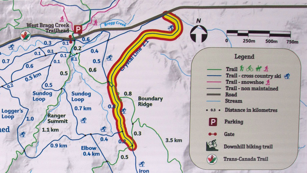
A short section of the Northern portion of Iron Springs Trail is currently closed due to logging activity in the area *Photo on Right *
|
|
|
Iron Springs
Trail Directions: (Iron Springs Southbound) From the Sundog Loop and Iron Creek Intersection, continue straight southbound on Iron Creek Trail. Shortly after crossing Strange Brew, there's a new logging road running uphill to the left. Keep right and continue southbound passing through a gate. A little further down, you'll cross over Boundary Ridge Trail where Boundary Ridge crosses over Iron Creek. At this point, Iron Creek veers east. Continue eastbound until reaching a T-junction. To the left is a number of unmarked trails. Turn right and head back westbound crossing over Iron Creek. A short distance later, you'll come to a shortcut. The trail to the right joins Elbow Trail and allows you to avoid the final 2km and 70m descent/ascent. (If you want to take the shortcut, turn right and continue for 50m before turning right northbound on Elbow Trail.) If you want to do the full loop, keep left and enjoy a great descent dropping down to the Elbow Trail intersection. Turn right to return to West Bragg on Elbow Trail (alternatively, continue southbound on Elbow Trail for 1.2km to join Snagmore, or 2.3km to Allen Bill Pond). Directions Continued below...
Elbow Trail Trail Directions Cont'd: (Elbow Trail Northbound) Climb north on Elbow Trail staying left at the shortcut and Snagmore intersections. Cross through another gate and ski alongside Iron Creek. Enjoy the beautiful meadows that run alongside the trail. There's a short black diamond option that provides some excitement and has the better run back southbound. Continue North down some fun descents. You'll reach the Sundog Loop Intersection not long after this. If you are using the Sundog loop to access this run, add another 3.3km onto the loop distance for the complete route distance from car to car.
|
Full Loop / Shortcut Loop
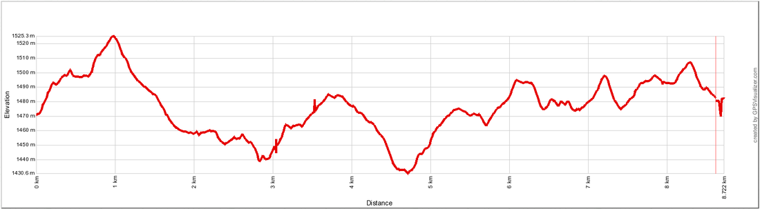
Distance: 8.8km / 6.8km Elevation Gain: 53 m Total Elevation Gain: 271m / 198m Time: 1.25 - 2. Hrs / 1 - 1.5 Hrs Iron Springs / Elbow Individual Trails (elevation stats for both trails are based on southbound travel) Distance: 4.9km / 3.9km Total Elevation Gain: 121 m / 95 m Total Elevation Loss: -159m / -145 m Time: .6 - 1.2 Hrs / .5 - 1 Hrs Physical Difficulty: 2/5 Technical Difficulty: 2/5 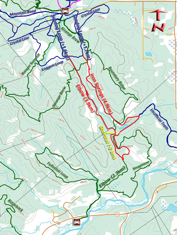
|
go to West Bragg Creek MTB Trails (click here)
go to Bragg Creek Area MTB Trails (click here)
go to Mountain Bike Trails (click here)
go to Mountain Bike Home (click here)
go to Bragg Creek Area MTB Trails (click here)
go to Mountain Bike Trails (click here)
go to Mountain Bike Home (click here)