Bragg Creek & Kananaskis Outdoor Recreation
  • Home
    • About Us
    • Contact Us
    • Terms of Use
    • Bragg Creek Hamlet >
      • Bragg Creek & Kananaskis History
  • Christmas Trees
  • Film Fest in Bragg Creek!
  • Events
  • Camp
  • Bike
    • Mountain Biking >
      • MTB Trails
      • MTB Groups
      • MTB Races
      • MTB Guidebooks
      • MTB Trail Etiquette
    • Cycling >
      • Favorite Road Rides
      • Cycling Groups
      • Cycling Races
  • Hike/Run
    • Hiking/Running Trails
    • Hiking >
      • Hiking Groups
      • Hiking Events
      • Hiking Guidebooks
    • Trail Running >
      • Trail Running Groups
      • Trail Running Races
      • Trail Running Guidebooks
  • Ski
    • Nordic/Snowshoe >
      • Nordic & Snowshoe Areas
      • Nordic & Snowshoe Groups
      • Nordic & Snowshoe Races
      • Nordic & Snowshoe Guidebooks
    • Backcountry Skiing >
      • Backcountry Skiing Areas
      • Backcountry Skiing Groups
      • Backcountry Skiing Guidebooks
  • Climb
    • Rock Climbing >
      • Popular Climbing Areas
      • Climbing Guidebooks
    • Alpine Climbing >
      • Popular Alpine Climbs
      • Alpine Climbing Guidebooks
    • Ice Climbing >
      • Ice Climbing Guidebooks
    • Climbing Groups
  • Paddle
    • Favorite Lakes
    • Favorite Rivers
    • Paddling Groups
    • Paddling Events
    • Paddling Guidebooks
  • Fish
    • Fishing Areas
    • Fishing Guidebooks
    • Fishing Groups
  • Picnic
    • Bragg Creek Area
    • Canmore Area
    • Central Kananaskis Area
    • Highwood Area
    • Peter Lougheed Area
    • Sheep River Area
    • Sibbald Area
  • Equestrian
    • Favorite Equestrian Areas
    • Equestrian Groups
    • Equestrian Events
    • Equestrian Guidebooks
  • Caving
    • Caving Areas
    • Caving Groups
    • Caving Guidebooks
  • Off-Highway Vehicles
    • Favorite OHV Areas
    • OHV Groups
    • OHV Races
  • Snowmobile
    • Favorite Snowmobile Areas
    • Snowmobile Groups
  • Logging Kananaskis!
    • Structure Retention Directive
    • Current Logging Plans
    • Logging vs. Recreation
    • How to Help!
  • Maps
  • Photos
  • Link Page

Elbow Valley & River View Loop

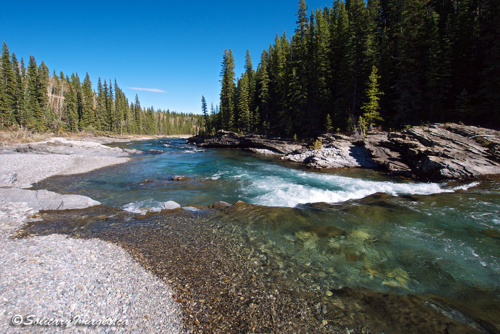
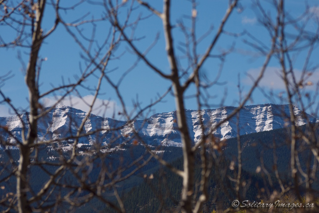
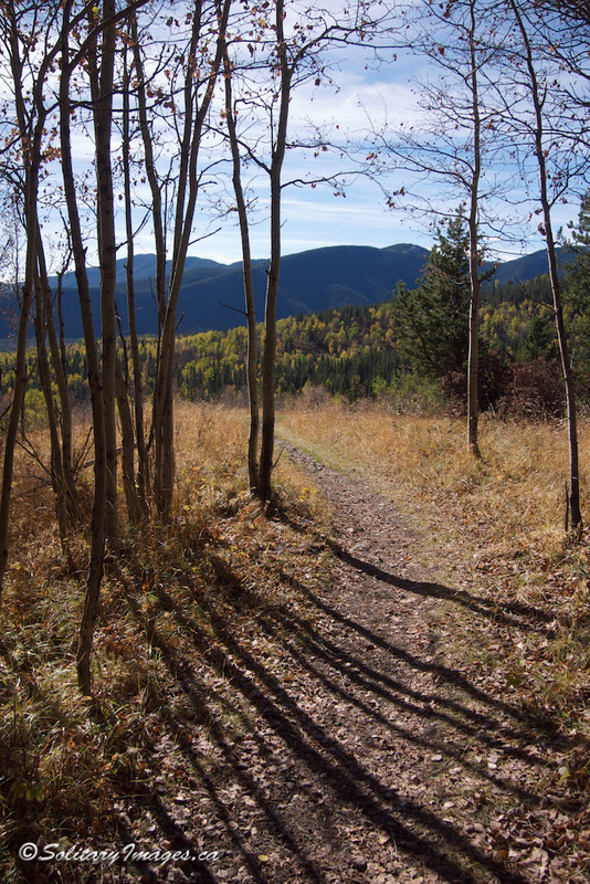
Excellent wilderness ride and a fall special incorporating Riverview and a portion of Elbow Valley Trail. This trail starts off through old school growth and majestic deciduous delicatessens followed by a stroll overlooking the Elbow river before dropping down along the riverside.

Picture
Picture
Picture
Picture
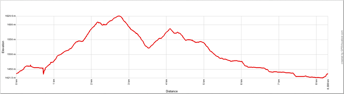
Distance: 8.3km return
Elevation Gain: 194m
Total Elevation Gain: 316m
Time: 2.5 -3.5 hours
Physical Difficulty: 2/5
Technical Difficulty: 2/5
Picture
Picture
Elbow Valley & River View Loop.gpx
File Size: 99 kb
File Type: gpx
Download File

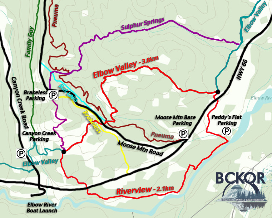
To Get Here: From the 4 way stop on HWY 22 next to Bragg Creek, take HWY 22 south to a T intersection. Turn right (westbound) on HWY 66. Travel 13.2 km west down HWY 66. Paddy's Flat entrance is on your left. Enter the campground and take your first right. Continue down this road to your third left into "Loop C " and a parking area on the right hand side near the entrance. Click here for a Campground Diagram.

Trail Description:

From the parking lot walk back towards highway 66 and look for an Elbow Valley trail head sign near the entrance of Loop C on the left. Follow this trail as it parallels the campground Road and crosses highway 66 near the campground entrance. Continue for a few meters to the Elbow Valley trail junction and turn left. Elbow Valley trail climbs through thick woods before opening up into serene meadows with magnificent views. Three kilometers west on Elbow Valley Trail, stay straight as you cross Pneuma, Moose Mtn Road and Brakeless before descending back down to the valley bottom. At 3.8km, watch for a four way intersection as Elbow Valley Trail crosses Riverview and Sulphur Springs Trail. Turn left and continue back across Highway 66 and on River View Trail. Follow alongside the river until you come to an obvious trail junction with a metal culvert on the right. Turn right and follow this down to the riverside where it wanders into the campground. You'll cross a bridge and see a marker with the number 11. Take a hard left turn and follow the trail a short distance back to the parking stall in the campground.

Return to Bragg Creek Area Hiking/Running Trails (click here)
Return to Hiking/Running Trails (click here)

Follow @BCKOR

Contact
Terms of Use
Copyright ©  2013-2014 Bragg Creek & Kananaskis Outdoor Recreation (BCKOR Ltd.) All Rights Reserved.