Peter Lougheed Fishing Area
Boasting some of the most scenic fishing in the world. Enjoy an afternoon fishing at a roadside lake or spend the day hiking to a distant mountain pond
Any fishing requires a license as well as adhering to specific rules and regulations for each body of water. Please visit Alberta Guide to Sportfishing Regulations for more info.
Any fishing requires a license as well as adhering to specific rules and regulations for each body of water. Please visit Alberta Guide to Sportfishing Regulations for more info.
Elbow Lake

A natural reproducing mountain lake, a short hike from the road. Clear shallow mountain water provides a great view of the days potential. Expect to find both Cutthroat and Brook Trout with the Brook Trout being dominant.
Hiking Directions: (~1 hour - 2.9km - 150m Elevation Gain) From the Elbow Pass Picnic area, follow the trail up a wide path to Elbow Lake. |
Click on "View Larger Map" on the bottom, to access a full size interactive map that can provide directions from your current location. |
Aster Lake
A true Alpine Lake that is high in the Kananaskis mountains next to Mount Joffre. Glacial silt from the Joffre glacier makes this lake quite cloudy, however it still produces trout and is worth casting a line if you're hiking past.
Hiking Directions: (10. 8km - 1650' elevation gain) From Upper Lake Day Use Area, hike clockwise around Upper Kananaskis Lake for 5.7km along the Upper Kananaskis Lake Circuit to a junction leading up the valley to Hidden Lake. If the lake is low enough, you can run around the left bank and continue on the trail. However if the lake is high, you'll have to climb over countless windfall that will slow your progress significantly. Continue another 5.1km, climbing steeply up from the valley bottom until you reach Aster Lake in the middle of a beautiful Alpine wonderland. For more info on the Aster Lake Campground visit: Backcountry Camping Sites |
To Get Here: From Trans Canada HWY 1, take Kananaskis HWY 40 south for 50km. Turn Right onto Kananaskis Lakes Trail. Follow Kananaskis Lakes Trail for 12. 5km to the Upper Kananaskis Lake parking lot. Click on "View Larger Map" on the bottom, to access a full size interactive map that can provide directions from your current location. |
Kananaskis Lakes
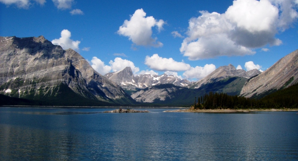
Kananaskis Lakes are the jewels of Kananaskis. With crystal clear water and a backdrop of alpine peaks. Kananaskis Lakes do provide boat launches and motorized boats are permitted on the lakes. Mainly Rainbow Trout are located in the Upper Lake with mainly Bull Trout located in the Lower Lake. Numerous Campgrounds surround this area offering an opportunity to stay next to this beautiful backdrop. For more information on the campgrounds visit: Central Kananaskis Campgrounds
|
To Get Here: From HWY 1 and HWY 40 intersection, head south down HWY 40 for 49.8km to Smith Dorrien Highway. Turn right, westbound down Smith Dorrien Highway and continue for another 2.2km to Kananaskis Lakes Trail on your left. Turn left on Kananaskis Lakes Trail and continue southbound for another 1.7km to the lower lake boat launch on the right or alternatively continue to the end of the road for the Upper Lake boat launch. Alternate access is available from Canmore via Smith Dorrien Trail and from Longview via HWY 541 and HWY 40 Click on "View Larger Map" on the bottom, to access a full size interactive map that can provide directions from your current location. |
Rawson Lake

A serene alpine lake in a beautiful bowl held high above Kananaskis Lakes, under the towering Mount Sarrail. A popular hiking trail for the views alone with the added bonus of being stocked with Cutthroat Trout. You'll have a hard time finding a more impressive place to cast a line.
Hiking Directions: (2.5km) From the end of the parking lot, follow the trail clockwise around the lake past Sarrail Falls. At about 1 kilometer, take the trail to your left and follow it up the steep hillside for 1.5km to Rawson Lake. |
To Get Here: From Trans Canada HWY 1, take Kananaskis HWY 40 south for 50km. Turn Right onto Kananaskis Lakes Trail. Follow Kananaskis Lakes Trail for 12. 5km to the Upper Kananaskis Lake parking lot. Click on "View Larger Map" on the bottom, to access a full size interactive map that can provide directions from your current location. |
Sparrow's Egg Lake
More info coming soon...
Hiking Directions: ~1.5km |
Click on "View Larger Map" on the bottom, to access a full size interactive map that can provide directions from your current location. |