|
It's all about the flow. High speed single-track trails running through pristine wilderness in the rolling foothills and mature forests located between the Prairies and the Rocky Mountains. An extensive trail network of cross country trails of varying length and difficulty allowing you to add on as many miles as your legs will allow. West Bragg is the premiere mountain bike location for all of Alberta and a great destination vacation for mountain bikers from all over.
Long Distance - Telephone Loop portion
|
To Get Here: Take Balsam Ave, just north of the 4-way stop on HWY 22 in Bragg Creek, West across the Elbow River bridge to a T intersection. Turn left onto Centre Ave. This section of road is 40km/hr for kids, pets and wildlife. Please slow down. Continue down Center Ave for 8.7 km to the West Bragg Creek Trail Recreation Area parking lot.
|
|
|
|
| ||||
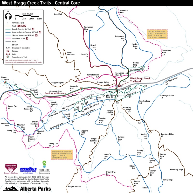
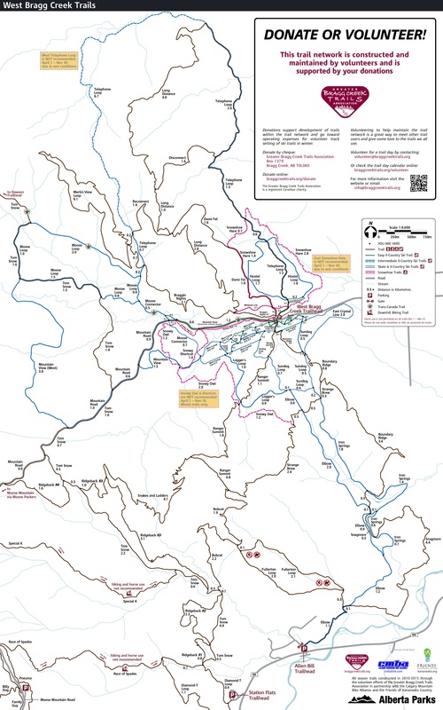
- Click here for current Trail Conditions
- Click on Highlighted names for full trail descriptions
All Season Trails - The driest trails used year round by MTB'rs
|
Name
Demi-Tel
Fullerton Loop (Hike only)
Snakes and Ladders
|
Distance
4.0 km
5.8 km
8.0 km
1.6 km
9.7 km
7.1 km
15.4 km
6.1 km
5.7 km
4.6 km
1.3 km
5.6 km
4.5km
4.7 km
18.8 km
|
Elev +/-
-270 m
212m/-149m
295 m
113 m
337 m
363 m
497m
204 m
254 m
335 m
80 m
138m/-206m
163m/-221m
350 m
693 m
|
Time
.25 - .5 Hr
.75 - 1.5 Hrs
.5 - 1.2 Hrs
.2 - .3 Hrs
1 - 2 Hrs
2 - 4 Hrs
1.5 - 3 Hrs
.5 - 1 Hr
.4 - .8 Hr
.75 - 1.5 Hrs
.1 - .3 Hrs
.75 - 1.5 Hrs
.6 - 1.2 Hrs
.75 - 1.5 Hrs
2 - 4 Hrs
|
Phys/Tech
2 / 3
2 / 2
2 / 2
2 / 1
2 / 2
2 / 2
3 / 2
2 / 2
2 / 1
3 / 2
2 / 2
2 / 2
2 / 2
3 / 2
3 / 2
|
Snowshoe / Fatbike Trails - Trails with a deep snowpack, great for snowshoeing or winter fatbiking
|
Name
Snowy Owl
Snowy Owl (Snowy Howl)
|
Distance
5.4 km
5.2 km
3. 2 km
|
Elev Gain
173 m
109 m
126m/-68m
|
Time
.75 - 1.5 Hr
.75 - 1.5 Hr
.4 - .8 Hr
|
Phys/Tech
2 / 3
2 / 3
2 / 3
|
Nordic Trails - Valley bottom trails designed around skiing. Often boggy but can be used in late summer by MTB's
|
Name
Bunny Loop
Chickadee Loop
Mountain View
|
Distance
0.4 km
0.4 km
2.8 km
3.5 km
3.9 km
4.0 km
4.8 km
2.9 km
1.5 km
6 km
2.4 km
1.5 km
3.8 km
12.7 km
|
Elev Gain
5 m
5 m
76m/-40m
90 m
95m/-145m
120 m
121m/-159m
155m/-47m
55 m
170 m
61m/-24m
64m/-41m
107 m
341m/-311m
|
Time
.1 - .2 Hr
.1 - .2 Hr
.3 - .6 Hr
.4 - .8 Hr
.5 - 1 Hr
.5 - 1 Hr
.75 - 1.25 Hr
.3 - .8 Hr
.2 - .4 Hr
.75 - 1.5 Hr
.25 - .5 Hr
.2 - .4 Hr
.5 - 1 Hr
3 - 6 Hr
|
Phys/Tech
1 / 1
1 / 1
1 / 1
1 / 1
2 / 1
2 / 2
2 / 1
2 / 2
1 / 1
2 / 2
1 / 1
2 / 2
2 / 2
3 / 2
|
Distance - based on car to car distance with the exception of traverses or trails that terminate at the start of another trail
Elevation Gain - total elevation gain
Time - based on car to card time with the exception of traverses, or trails that terminate at the start of another trail
Physical / Technical - difficulty based on a scale of 5 with 1 being easiest and 5 being hardest
Elevation Gain - total elevation gain
Time - based on car to card time with the exception of traverses, or trails that terminate at the start of another trail
Physical / Technical - difficulty based on a scale of 5 with 1 being easiest and 5 being hardest
go to Bragg Creek Area MTB Trails (click here)
go to Mountain Bike Trails (click here)
go to Mountain Bike Home (click here)
go to Mountain Bike Trails (click here)
go to Mountain Bike Home (click here)