Situated in the middle of the foothills, Sibbald Area consists of open meadows, gentle ridges and valleys full of elk, deer, bear, moose and birds. There are numerous equestrian and snowmobile trails as well as handful of mountain bike and hiking trails located here.
If you plan on having a fire, please check Alberta Fire Bans, to see if there are any restrictions first.
If you plan on having a fire, please check Alberta Fire Bans, to see if there are any restrictions first.
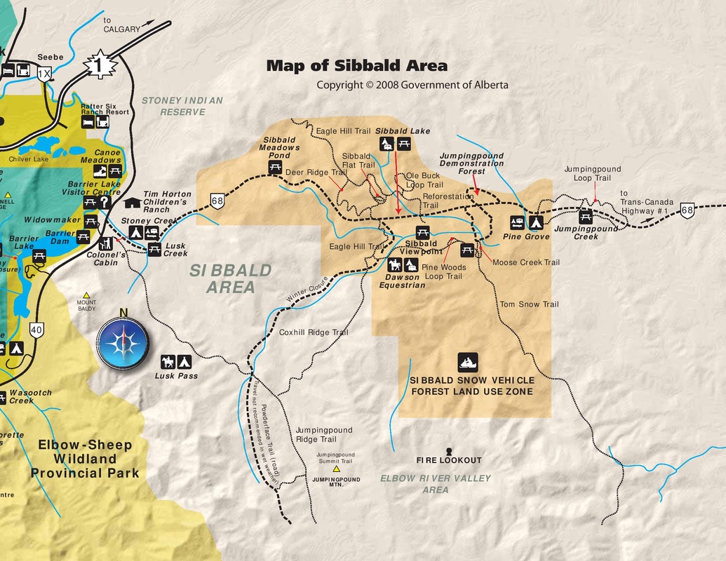
_Map(s) produced by Kananaskis Region | Parks Division | Tourism, Parks and Recreation Ministry, Government of Alberta
| Click to Download Interactive Map |
Pine Grove (Group Site)
|
To Get Here: From HWY 1, take HWY 68 for 15.6km to the campground on the left. Alternate access is available from the west through HWY 40 and the south through Powderface Road and HWY 66 (open May 15 - Nov 30) |
Sibbald Lake
A great family getaway with a stocked lake in the middle of the campground as well as riding opportunity in the Sibbald area.
|
To Get Here: From HWY 1, take HWY 68 for 22km to the campground on the right. Alternate access is available from the west through HWY 40 and the south through Powderface Road and HWY 66 (open May 15 - Nov 30) |
Dawson (Equestrian)

Off the beaten path, this campground provides great access to riding up and down Powderface Trail or in the Sibbald area.
|
To Get Here: From HWY 1 east, take HWY 68 south for 23km to Powderface Trail. Take Powderface Trail south for 3.1km to the Campground. Alternate access is available from the west through HWY 40 and the south through Powderface Road and HWY 66 (open May 15 - Nov 30) |
Stoney Creek (Group Site)
A great spot for playing on the Kananaskis River, spending the day on Barrier Lake or riding in Sibbald Area.
|
To Get Here: Take HWY 40 south for 7.7km to HWY 68. Turn down HWY 68 and continue for 850m to the campground on your right. Alternate access is available from the west through HWY 40 and the south through Powderface Road and HWY 66 (open May 15 - Nov 30) |
go to Campground Areas (click here)
go to Backcountry Campgrounds (click here)
go to Bragg Creek Campgrounds (click here)
go to Canmore & Spray Lake Campgrounds (click here)
go to Ghost Area Campgrounds (click here)
go to Highway 40 Campgrounds (click here)
go to Highwood Campgrounds (click here)
go to Peter Lougheed Campgrounds (click here)
go to Sheep River Campgrounds (click here)
go to Sibbald Campgrounds (click here)