West Bragg Creek Nordic Trails
|
West Bragg Creek Trails have many cross country ski and snowshoe trails that wind throughout the beautiful foothills. These trails are maintained and track set on a volunteer basis by the Greater Bragg Creek Trails Association. Support them with your donation, and receive up-to-date ski-grooming reports via email, within 12 hours of grooming. 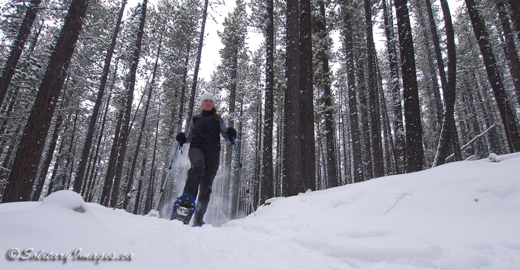
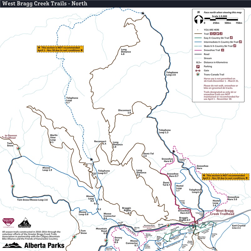
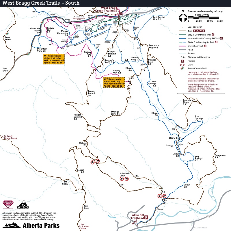
Braggin' Rights - West Bragg Creek Trails
|
To Get Here: Take Balsam Ave, just north of the 4-way stop on HWY 22 in Bragg Creek, West across the Elbow River bridge to a T intersection. Turn left onto Centre Ave. This section of road is 40km/hr for kids, pets and wildlife. Please slow down. Continue down Center Ave for 8.7 km to the West Bragg Creek Recreation Area.
|
|
|
|
| ||||
- Click here for current Trail Conditions
- Click on Highlighted names for full trail descriptions
All Season Trails - The driest trails used in the winter by MTB'ers, Hikers and Snowshoers
|
Name
Bobcat (MTB/Hike/Snowshoe)
Boundary Ridge (MTB/Hike/Snowshoe)
Braggin' Rights Loop (MTB/Hike/Snowshoe)
Demi-Tel (MTB/Hike/Snowshoe)
Disconnect Loop (Hike/Snowshoe)
Fullerton Loop (Hike/Snowshoe)
Long Distance (MTB/Hike/Snowshoe)
Ranger Summit (MTB/Hike/Snowshoe)
Reconnect (MTB/Hike/Snowshoe)
Snagmore (MTB/Hike/Snowshoe)
Strange Brew (MTB/Hike/Snowshoe)
Sugar Mama Loop (MTB/Hike/Snowshoe)
|
Distance
4.0 km
5.8 km
8.0 km
1.6 km
9.9 km
7.1 km
15.4 km
6.1 km
4.6 km
1.3 km
5.6 km
4.7 km
18.8 km
|
Elev +/-
270 m
212m/-149m
295 m
113 m
337 m
363 m
497 m
204 m
335 m
80 m
138m/-206m
350 m
693 m
|
Time
.75 - 1.5 Hrs
1.25 - 2.5 Hrs
2 - 3.5 Hrs
.3 - .5 Hrs
2.5 - 5 Hrs
2 - 4 Hrs
5 - 7 Hrs
1.5 - 2 Hrs
1.25 - 2 Hrs
.2 - .3 Hrs
1.25 - 2.25 Hrs
1 - 2.5 Hrs
5 - 8 Hrs
|
Phys/Tech
2 / 3
2 / 2
2 / 2
2 / 1
2 / 2
2 / 2
3 / 2
3 / 2
3 / 2
2 / 2
2 / 2
3 / 2
3 / 2
|
Snowshoe / Fatbike Trails - Trails with a deep snow-pack, great for snowshoeing or fatbiking.
|
Name
Snowshoe Hare Loop (Snowshoe / Fatbike)
Snowy Owl (Snowshoe / Fatbike)
Snowy Owl (Snowy Howl) (Snowshoe / Fatbike)
|
Distance
5.4 km
5.2 km
3.2 km
|
Elev +/-
173 m
109 m
126m/-68m
|
Time
1.25 - 2 Hrs
1 - 1.75 Hrs
.75 - 1.25 Hrs
|
Phys/Tech
2 / 2
2 / 2
2 / 2
|
Ski Trails - Trails maintained for x-country skiing (Please do not hike, bike or snowshoe on groomed trails)
|
Name
Bunny Loop (X-Country Ski Only)
Chickadee Loop (X-Country Ski Only)
Crystal Line East (X-Country Ski Only)
Crystal Line West (X-Country Ski Only)
Elbow Trail (X-Country Ski Only)
Hostel Loop (X-Country Ski Only)
Iron springs (X-Country Ski Only)
Logger's Loop (X-Country Ski Only)
Moose Connector (X-Country Ski Only)
Moose Loop (X-Country Ski Only)
Mountain Road Cnctr (X-Country Ski Only)
Mountain View (X-Country Ski Only)
Sundog Loop (X-Country Ski Only)
Telephone Loop (X-Country Ski Only)
|
Distance
0.4 km
0.4 km
2.8 km
3.5 km
3.9 km
4.0 km
4.8 km
2.9km
1.5 km
6 km
2.4 km
1.5 km
3.8km
12.7km
|
Elev +/-
5 m
5 m
76m/-40m
90 m
95m/-145m
120m
121m/-159m
155m/-47m
55 m
170 m
61m/-24m
64/-41 m
107m
341m/-311m
|
Time
.1 - .2 Hr
.1 - .2 Hr
.3 - .6Hr
.4 - .8 Hr
.5 - 1 Hr
.5 - 1 Hr
.6 - 1.2 Hr
.4 - .8 Hr
.2 - .4 Hr
.75 - 1.25 Hr
.3 - .6 Hr
.2 - .4 Hr
.5 - 1 Hr
3 - 5 Hr
|
Phys/Tech
1 / 1
1 / 1
1 / 1
1 / 1
2 / 2
2/3
2 / 1
2 / 3
2 / 2
2 / 2
1 / 1
2 / 2
2 / 2
3 / 2
|
Distance - car to car distance with the exception of traverses or trails that end/begin at the start of another trail
Elevation Gain - total elevation gain including gain/loss on one way routes and elevation loss on downhill routes
Time - based on car to car time with the exception of traverses or trails that end or begin at the start of another trail
Physical / Technical - difficulty based on a scale of 5 with 1 being easiest and 5 being hardest